The La Niña phenomenon is leaving predictions for temperatures and precipitation in the upcoming winter months uncertain for Iowa.
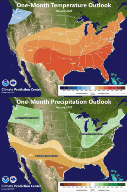
According to the National Ocean Service, La Niña is sometimes referred to as the cold phase of the El Niño-Southern Oscillation cycle, which describes the fluctuations in temperature between the ocean and atmosphere in the east-central Equatorial Pacific. Meteorologist Ray Wolf from the National Weather Service Quad Cities Office says that because of La Niña the odds lean toward colder than normal weather in the northwest part of the U.S., and warmer than normal conditions in the southern portion. Wolf says in La Niña systems Iowa typically trends toward the cold and snowy side, though that isn’t certain as there are other factors that influence the climate conditions, “It looks like at this point there’s not a strong signal for us toward the colder or warmer side. Like I said up in the northern plains the signal is stronger for colder up that way. There is a hint that maybe we could start trending toward the wetter than normal side from January into February which wouldn’t be too bad of a thing because we’ve been pretty dry in the last couple of months, so there are no concerns from a flooding or soil moisture standpoint at this time.”
The National Weather Service’s climate outlook issued in December predicts that most of the central region of the U.S. is favored to see warmer than normal temperatures while North Dakota and Minnesota have near equal chances of above, near or below normal temperatures. Iowa does appear to be in a “no man’s land” as Wolf puts it for a precipitation outlook, as it is predicted to be above normal around the Great Lakes Region and drier than normal across western Kansas and eastern Colorado.

