

Washington is expected to see its first large weather event of the season, as a Winter Storm Warning is in effect from 6 a.m. Saturday until midnight Saturday night.
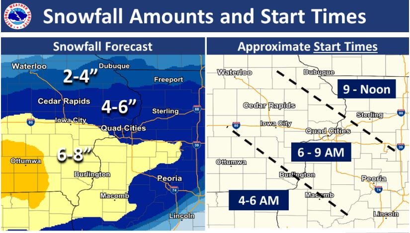
The National Weather Service Quad Cities Office anticipates snow accumulation of four to eight inches possible in southeast Iowa with heavier amounts and light ice accumulations possible south of Interstate 80. Washington City Maintenance and Construction Superintendent JJ Bell says in the case of large predicted snow events he has all of his staff on call to respond, “We usually get out there before the snow is ending to at least hit priorities, might actually pre-salt priorities too before the snow even comes down just to kind of help on that having to go out at night or whatnot. Then again the plow routes take anywhere from four to six hours to plow, kind of dependent on the kind of snow, how much snow. And we usually get the loaders and the maintainers up on the square after midnight to clean the downtown area.”
The city typically sends out nine staff members to plow streets during a major event, with priority routes including Lexington Boulevard and West 5th Street, South Iowa Avenue and streets leading up to the county ambulance garage and fire station. Bell encourages residents to move their vehicles to off-street parking areas to help their clearing operations, and to clear snow from fire hydrants when shoveling sidewalks and driveways. Travel could be very difficult Saturday especially in the evening, with gusty winds leading to blowing snow and reduced visibility. Residents should also bundle up, as dangerously cold wind chills as low as 15 to 25 degrees below zero are forecasted Saturday night.
Winter weather is also occurring Friday in southeast Iowa with the National Weather Service issuing a winter weather advisory for freezing rain with accumulating ice possible from 11a.m. to 6p.m.
Listen to KCII for weather updates.