

The KCII listening area dealt with winter weather over the past several days thanks to a major storm complex that impacted most of the midwest. The National Weather Service in the Quad Cities issued a Winter Storm Warning for the entire KCII listening area during a portion of Monday and all of Tuesday. The highest snowfall total was reported in Frytown and Sharon Center in southern Johnson County with 13 inches each. Other reports included 12 inches near Fairfield in Jefferson County, 11 inches each in Washington and Sigourney, 10 inches in Riverside and eight inches in New London in Henry County.
According to a Washington County Communications report, a total of thirty-two weather related calls were placed, including those for vehicles sliding off the road and entering ditches, and semis jack-knifing and blocking lanes. Another major impact of the snow accumulation was breaking tree branches and power lines being affected. According to information from Alliant Energy, initial power outages were reported in portions of Washington, Keokuk, Henry and Jefferson Counties and Tuesday, with some customers still without power Wednesday.
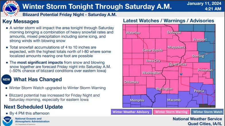
The next round of snow for the listening area is expected to begin late Thursday. The National Weather Service in the Quad Cities has issued a Winter Storm Warning for the entire KCII listening area from 9p.m. Thursday, January 11th to noon Saturday, January 13th. Heavy snow, mixed precipitation and significant blowing snow are expected during this time. Total snow accumulations of five to 10 inches with ice accumulations around one tenth of an inch are forecast. Wind gusts up to 50mph are possible. Travel will be very difficult. Blowing snow will significantly reduce visibility. Blizzard conditions are expected. Downed tree branches and power lines are possible. If you must travel, take a winter emergency preparedness kit that includes a flashlight, food, water and blankets.
Stay tuned to KCII for weather updates.